
Christmas Bay
The Christmas Bay Paddling Trail is a Texas Parks and Wildlife (TPWD) paddling trail, and PACK partners with TPWD on it. It is a 19.1-mile loop around this shallow, unspoiled bay at the western end of the Galveston Bay system, an easy drive from Houston, with great fishing and bird watching. The north shore is the Brazoria National Wildlife Refuge.
Routes
- Short loop, 3.8 miles: markers 1, 2, 22, 21, 20, 18, 17, 7, 6, 5, 4, 3, 2, 1
- Longer loop, 10.3 miles: markers 1, 23, 24, 25, 26, 27, 28, 29, 10, 9, 3, 2, 1
- Whole trail: 19.1 miles, including Churchill Bayou and Titlum Tatlum Bayou
Launch points
- Amigo Lane (former site of Ernie's Too Bait Camp, now closed), 515 Amigo Ln, Freeport: the trail marker sign is near the boat ramp. Open in Google Maps
- San Luis County Park, 14001 CR 257, Freeport: on the right of Bluewater Hwy 257 just after the San Luis Bridge; follow the dirt road to the park and boat dock. Open in Google Maps
Before you go
Take plenty of sunscreen, water and insect repellent. The bay is very shallow (most paddlers can stand in most places) and has little power-boat traffic. If you wade-fish, wear stingray-proof boots or shuffle your feet.
More on TPWD's Christmas Bay Paddling Trail page. Questions? Use the Christmas Bay questions form.
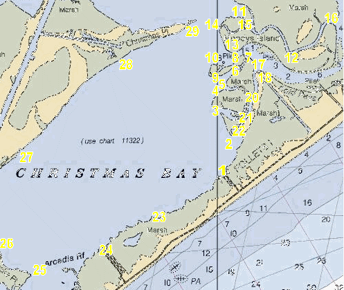
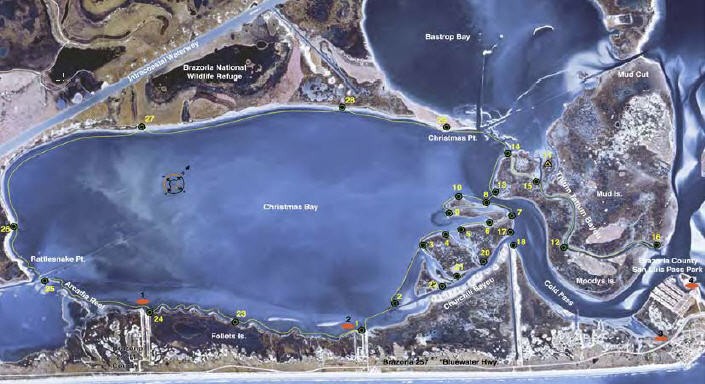
The trail's 29 numbered markers, as latitude and longitude in degrees and decimal minutes (dd° mm.mmm'), from TPWD's GPS points. Marker 9 is from PACK's own survey (TPWD doesn't list it).
| Marker | Name | Latitude | Longitude |
|---|---|---|---|
| 1 | Ernie's Too Bait Camp | 29° 02.934' N | 95° 09.937' W |
| 2 | Big Mama's | 29° 03.191' N | 95° 09.872' W |
| 3 | Little Churchill Bayou | 29° 03.767' N | 95° 10.048' W |
| 4 | 29° 03.963' N | 95° 09.977' W | |
| 5 | Mud Flat | 29° 04.081' N | 95° 09.853' W |
| 6 | 29° 04.275' N | 95° 09.640' W | |
| 7 | Cold Pass | 29° 04.424' N | 95° 09.582' W |
| 8 | Cold Pass | 29° 04.401' N | 95° 09.770' W |
| 9 | 29° 04.109' N | 95° 09.998' W | |
| 10 | Cold Pass | 29° 04.169' N | 95° 10.000' W |
| 11 | 29° 04.934' N | 95° 09.661' W | |
| 12 | Titlum Tatlum Bayou | 29° 04.470' N | 95° 08.012' W |
| 13 | Cold Pass | 29° 04.466' N | 95° 09.799' W |
| 14 | Titlum Tatlum Bayou | 29° 04.799' N | 95° 09.929' W |
| 15 | Titlum Tatlum Bayou | 29° 04.777' N | 95° 09.542' W |
| 16 | Titlum Tatlum Bayou | 29° 04.854' N | 95° 08.680' W |
| 17 | Churchill Bayou | 29° 04.291' N | 95° 09.421' W |
| 18 | Churchill Bayou | 29° 04.216' N | 95° 09.403' W |
| 19 | 29° 03.911' N | 95° 09.115' W | |
| 20 | Churchill Bayou | 29° 03.956' N | 95° 09.443' W |
| 21 | Churchill Bayou | 29° 03.698' N | 95° 09.550' W |
| 22 | Churchill Bayou | 29° 03.644' N | 95° 09.581' W |
| 23 | South Shore | 29° 02.427' N | 95° 10.951' W |
| 24 | Cedar Cut | 29° 02.021' N | 95° 11.612' W |
| 25 | Arcadia Reef | 29° 01.770' N | 95° 12.558' W |
| 26 | Rattlesnake Point | 29° 01.986' N | 95° 13.019' W |
| 27 | North Shore | 29° 03.203' N | 95° 12.739' W |
| 28 | North Shore | 29° 04.334' N | 95° 11.360' W |
| 29 | Christmas Point | 29° 04.818' N | 95° 10.316' W |
Help check the markers
PACK helps look after this trail. If you paddle it, note each marker you pass:
- F: found at the coordinates, in good condition
- D: found but damaged (say what's wrong)
- X: not found
Send what you found through the Christmas Bay questions form, or bring it to the next PACK meeting.