|
Jones Bay Trip
January 23, 2010
|
| |
| Trip Description: |
| |
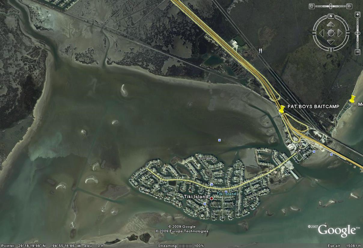
Day Trip. Launch Point is Fatboys Bait Camp at 7:00am Oyster shell reefs, scattered shell and soft and firm mud bottoms make up this terrain in Jones Lake which is located just off I-45 going to Galveston and sits behind Bayou Vista’s and Tiki Island Bay Home subdivisions. This upper coast area just off of West / Galveston Bays provide prime habitat for redfish, trout, black drum, flounder, and sheepshead. You can paddle south to fish under the causeway, you can paddle east to fish all along the grass line. It is an easy paddle in mostly shallow water. You can keep paddling east and fish the entrance to Highland Bayou. Weather will be moderately warm 56-67 degrees but water will be a lot colder. Chance for thunderstorms – be prepared for it.
Winter Time (January – February - March ) This bays system has numerous guts and some deep water areas (4 to 7 feet deep) out in the center of the lake start moving. The average air temperature is 62 degrees Fahrenheit for the month of January.
Skill Level: Beginner
Note Paddling distance is approximately 1 to 1.5 miles and to the far shoreline of Jones Bay is approximately 2 miles. Protection from N or NNE winds can be obtained by paddling about a ½ mile to NE shoreline ie. Jones Bay Shoreline.
|
| |
| Leader: |
| |
Adrian Ramos – aka ramosad or camoyak, click here to email, 832-526-5677 832-526-5677
|
| |
| Date/Time: |
| |
We will meet at Fat Boys Bait / Camp (also known as Jones Bay/I-45 Public Boat Ramp at 7:00 a.m., Saturday, January 23, 2010.
GPS coordinates are N29 18.360’, W94 54.410’
Published Fat Boy Phone #’s 409-935-4151 409-935-4151 or 409-457-1489 409-457-1489
Donuts/Kolaches will be served at 7:30 a.m. sharp. BYOC (Bring your own coffee)
Please sign in on Trip – ‘Paddle Out List’ upon arrival and sign out upon return. Communication will be maintained on VHF Radios and will be tuned to Channel 69.
|
| |
| How to Sign Up: |
| |
If you want to go, contact the trip leader (or sign up at a monthly meeting) and provide: name, email address and phone number (preferably cell phone). or Register for a PACK login account and then use the Auto Enroll link above to automatically have your name added to the list below.
|
| |
| How to Get There: |
| |
From Houston: (located at I-45S and Santa Fe Overpass just before the Galveston Island Causeway Bridge.)
1. Take I-45 South to Galveston
2. Take exit for Tiki Island, at the stop sign turn right
3. Heading North back toward Santa Fe overpass you will see Fat Boy’s Bait Camp
|
| |
| MAPS / Photos of Interest: |
| |
|
| |
| What to Pack/Bring: |
| |
See Standard PACK List for items to consider for any PACK outing
Important items:
- VHF Radio for communication and emergency contact
- First Aid Kit
- Lunch, Water, snacks
- Kayak Drift Sock
|
| |
| REQUIRED READING: |
| |
Recommended guidelines for participates:
- Make sure trip leader or an officer has your emergency contact
- Notify the trip leader if you have any potential concerns
- If inexperienced, then buddy up. Make sure the trip leader knows your experience level
- Communicate with the trip leader, if you are unsure of your skill level required
- Member dues are current
- Guests are invited to particpate
- Have performed deep water entries
- Cary a first aid kit
- Have a life jacket
- Have a VHF radio
- Inform the trip leader of your float plan if planning to fish alone or longer then the designated times.
- Sign in and sign out at the launch site. Inform the trip leader if you will be launching in a different place.
Recommended for Trip Leaders:
- Insures proper authorizations
- Secure sites
- Prepare emergency preparedness plan
- Keep abreast of weather conditions that might effect the trip
- Point out any potential area hazards
- Maintain a head count
- Have available a first aid kit
- Have a VHF radio
|
| |
|
Expenses/Fees:
|
| |
None
|
| |
| Fishing Options: |
| |
Other optional fishing venues off Jones Lake include North and South Deer Islands, Bastrop Bayou Mouth, Diversionary Canal Mouth, Flamingo Isle Slips, and Highland Bayou Mouth. Here are some key GPS coordinates for Jones Lake. These other areas mentioned can be seen on the TOP SPOT Fishing Map.
Jones Bay Reef (Drift Fishing deep guts and reefs)– N29 17.806’, W94 56.208’
Jones Bay Shoreline (Wading, or Kayak-crab-walking) – N29 18.610’, W94 55.164’
Jones Lake Reef #1 (Drift Fishing deep guts and reefs) – N29 17.650’, W94 55.930’
Jones Lake Reef #2 (Drift Fishing deep guts and reefs) - N29 17.900’, W94 56.070’
|
| |
| Guest Participants: |
| |
(We prefer for you to create a login account on this website so that you can have your name added to the auto register list below. If you don't have a registered login account on this website we can list your name here; please contact the trip leader to request your name to manually added. If you have a login account then use the enroll feature at the top of this page to become part of the auto enroll list below)
-
-
|
| |